Navigation Instruments
Weather vanes were found on every ship. They showed the wind direction so the
coxswain paid close attention to which direction it pointed after they lost
sight of land. But it was easy to be fooled. The
wind could change direction and the current could send the ship off course.
It was therefore necessary for the skipper to have navigation instruments.
 |
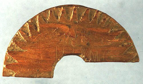
The Vikings had knowledge of a primitive bearing circle. It was based on
information about the sun's position at sunrise and sunset. You could find
the latitude with the help of a shadow from the vertical pin and the
course was marked by the pointer on the platform. A primitive bearing
circle was found on Řsterbygda in Greenland, but it is uncertain if this
was the same type of bearing circle in use at a later time. |
|
The Vikings used the so-called sun stone in order to find the sun on
overcast days. The stone was made of the mineral cordierite, a mineral
that could show the direction of the sun on cloudy days. The sun stone
could only be used when one could see a hint of blue sky.
|
 |
In the middle of the day the course was corrected with the help of the
sunboard. This was an instrument used to measure the height of the sun. If
the angle of the sun had gotten much bigger the ship had kept a too
southerly course, less of an angle and it had sailed too far north. In
cloudy weather or in a fog it was therefore difficult to navigate. Making
a course change on the open sea could be risky. Just a small change could
result in not coming to the planned destination.
Ottar from Hĺlogaland in telling about his
voyage to the White Sea about 880 said that when he made a course
change it was with land in sight not on the open sea.
|
Seafarers made many observations of the sun all year round and they knew the
sun's path through the heavens for all the seasons. There is a table that was
written in Iceland. The table gives the height of the sun for the whole year
along with a rundown of sunrises and sunsets. Here you can find where on the
horizon the sun goes down and comes up the whole year. All the measurements from
this table were put on the so-called semi-wheel. It was then not difficult to
find the four directions nor calculate the latitude. It was perfectly natural
that guides for seafarers were produced even though the sagas tell us nothing
about this.
They often had to find their way back to previously discovered sights by mere
chance, places like Iceland and America.
|